
Bob Thomas, a longstanding IGS member, has died at the age of 77
Robert H. (Bob) Thomas was born 1 June 1937, in Hoylake, UK. He passed away on 2 February 2015, in Gorzow, Poland, from the effects of a stroke that he suffered in early January. He was 77. Bob is survived by his wife, Dr Roma Thomas, MD; five children (Conrad and Emma with Roma Thomas, James and Clare from a previous marriage with Ursula Chojnacka, and a daughter Kate from his first marriage with Pamela); and four grandchildren (Emmanuelle, Charlotte, Zachary and Jasper).
Bob’s interest in glaciology began during a 2-year Antarctic deployment (1960–61), as a meteorological observer at Faraday Station, on Galindez Island, where he found himself intrigued by the flow of nearby ice caps. Spending his free time learning to survey stake networks with optical surveying equipment, he developed a deep respect for the power of observation in interpreting the moving glacier ice all around him. Later in life he would say, ‘My driving principle was to measure everything I could about ice.’
Following his deployment to Faraday Station, and after traveling for a time through South America, Bob returned to the UK intent on becoming a professional glaciologist. He returned to Antarctica in 1966/67 as a field assistant with the British Antarctic Survey (BAS) team at Halley Bay Station. Sir Vivian Fuchs ran BAS at the time, and those assigned to the station, which they found buried under 10 m of snow on the edge of the Brunt Ice Shelf, still possessed the British spirit of exploration.
At Halley Bay, Bob was true to his driving principle and ‘measured the hell out of the Brunt Ice Shelf and its adjoining bit of ice sheet’. As he gathered more data from his stake networks and strain rosettes, he began to notice that the strain rates along a flow line leading from the inland ice sheet and across the grounding line to the calving front of the ice shelf were strongly influenced by a patch of grounded ice shelf called the McDonald Ice Rumples (then called the Gin Bottle). Bob boldly drew a connection between the ice rumples, the flow of the ice shelf, and flow across the grounding line. Bob explained this connection years later: ‘Afterwards [after returning from Halley Bay], back in Cambridge, I was able to use all these measurements to show how important the Gin Bottle was to the existence of the Brunt Ice Shelf, and this discovery has since been the foundation stone upon which I have built an hypothesis describing the stability of the Antarctic ice sheet under attack from climate warming. In this scenario, the ice shelves are the dams that prevent accelerated discharge of much of the ice sheet into the ocean. Weakening of the peripheral ice shelves would open a door to greatly accelerated discharge of much of the inland ice sheet into the ocean, resulting in sea-level rise.’
Bob’s work with the Brunt Ice Shelf data, which he acquired using optical survey instruments, tape measures and dog sleds, led him to publish his theory of ice-shelf buttressing of the inland ice sheet feeding the shelves.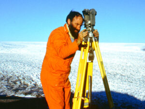
The concept of ice-shelf buttressing, that the forward flow of inland ice across grounding lines is resisted by the floating ice shelves seaward of grounding lines, because of their confinement in embayments whose margins provide shear resistance, with additional resistance provided by high points on the sea floor that intersect the bottom surfaces of the floating shelves forming ice rises, became a major theme of his life’s work. It is writ large today; Bob’s phrase, ‘ice-shelf buttressing’, is the subtitle of a section of the 2013 Intergovernmental Panel on Climate Change (IPCC) Fifth Assessment Report (AR5).
Armed with his data from the Brunt Ice Shelf, Bob began work on a PhD at the Scott Polar Research Institute (SPRI) in Cambridge, UK. There he was exposed to the local luminaries of UK glaciology; his thesis was mentored by Charles W.M. Swithinbank (1926–2014) and Gordon deQ. Robin (1927–2004) and, in addition, to prominent visitors well known for advancing glaciological research. They included Johannes Weertman (of Northwestern University, USA), who had formulated the first quantitative description of ice-shelf flow and was working on his soon-to-be-published paper showing that a marine ice sheet such as that of West Antarctica is not necessarily stable, and William F. (Bill) Budd (of the University of Melbourne, Australia), who æ in addition to his many contributions to the physics of ice deformation and flow – was an early developer of computational ice sheet modeling.
Bob completed and defended his PhD dissertation, entitled ‘The Dynamics of the Brunt Ice Shelf, Coates Land, Antarctica’, in 1972. It was published as British Antarctic Survey Scientific Report No. 79 in 1973.
Bob expressed an iconoclastic view of Antarctic field work; it was that in the wake of the International Geophysical Year (IGY, 1 July 1957–31 December 1958), much of what was going on in Antarctica was simply mapping ‘what was there’. He believed early in his career that field work should be strategic, designed to answer scientific questions beyond simply making maps. One of his ideas was to follow-up on how ice shelves influence the flow of ice streams – ice sheet analogies to ocean currents – across their grounding lines. The great ice streams of the Marie Byrd Land sector of the West Antarctic ice sheet that discharged into the Ross Ice Shelf had then been discovered through an airborne radar-survey program carried out, in part, by his mentors and colleagues at Scott Polar Research Institute.
Bob’s progressive views of what an observational program in glaciology could deliver were noticed by the scientists who were organizing what would become the most ambitious field survey to date of a large component of the Antarctic Ice Sheet: the Ross Ice Shelf. In 1973 he was hired by the Ross Ice Shelf Project (RISP) Office with support from H. Jay Zwally, then program manager for Antarctic and Arctic glaciology in the US National Science Foundation (NSF) Office of Polar Programs.
Bob teamed with Charles R. Bentley (of the University of Wisconsin Madison), a pioneer of Antarctic geophysics, to form a subproject called the Ross Ice Shelf Geophysical and Glaciological Survey (RIGGS). Earlier, Charles and Ned A. Ostenso had discovered – from analysis of the extensive seismic data they acquired during a series of long traverses across the inland West Antarctic ice sheet (WAIS) during 1957–60 – that WAIS is a marine ice sheet grounded far below sea level.
Bob, Charles Bentley and their graduate students planned and carried out a full and systematic survey of the glaciology and geophysics of the ~487 000 square kilometer Ross Ice Shelf, including ice-shelf thicknesses, gravity anomalies, strain rosettes from which principal strain rates and flow velocities were subsequently derived, surface accumulation rates, and 10 m temperatures on a 50 km grid. They used de Havilland Twin Otter aircraft support and fly-in camps to accomplish the survey during 1973–78.
While working with Charles Bentley on RIGGS, Bob moved, at the invitation of glaciologist Terence J. Hughes (of the University of Maine), from the University of Nebraska, which was hosting the Ross Ice Shelf Project, to the Institute for Quaternary Studies at the University of Maine. There he joined Terence, glacial geologist George H. Denton and mathematician/numerical analyst David H. Schilling (on sabbatical from the University of Wisconsin-Barron County) who, in addition to working on problems of present ice flow in Antarctica and Greenland, were also participating in the multi-university NSF-funded Climate: Long Range Investigation, Mapping, and Prediction (CLIMAP) project. Douglas R. MacAyeal (whose BS in physics was from Brown University) joined Bob as an MS graduate student in physics, carried out field work with him on the Ross Ice Shelf, and developed the first comprehensive finite element model of a large component of the Antarctic ice sheet, the Ross Ice Shelf. Craig S. Lingle (whose BS in electrical engineering was from the University of Washington) joined Terence as an MS graduate student in geological sciences, worked on the CLIMAP ice sheet reconstruction, then subsequently worked with Terence, Bob and Ronald Kollmeyer (of the US Coast Guard) on a Coast Guard-supported survey of the floating, iceberg-calving Jakobshavns outlet glacier in West Greenland.
Over a period of about 5 years, Bob’s interaction with the University of Maine group resulted in some of the best forward thinking that guides ice sheet glaciology to this day. His disciplined observations and thinking about the Brunt and Ross ice shelves culminated, in the late 1970s and early 1980s, in a prolific series of papers on marine ice sheet instability, ice stream grounding line dynamics and the controlling roles of the ice shelves. These included a 1979 paper published in Nature in which, with Timothy J.O. Sanderson (then of BAS) and Keith E. Rose (then of SPRI), Bob suggested, based on his time-dependent ice stream grounding line model (developed in collaboration with David Schilling), that substantial degradation and thinning of the Ross Ice Shelf could result in disintegration of WAIS in a few centuries, resulting in a mean sea-level rise of 5 m.
In this, Bob was among a handful of visionary glaciologists who responded to the proposition first put forward by John H. Mercer (1922–87) in 1968, then in a paper published in Nature in 1978, that irreversible retreat of the West Antarctic ice sheet could be initiated by greenhouse warming of the Earth’s climate.
Bob’s ventures into theoretical ice-sheet glaciology must have been satisfying, but he always maintained a conviction that field observations were critical for progress in understanding how ice sheet stability and sea-level rise would be linked to future climate changes.
In 1980 Bob joined the glaciologists of the Oceans and Ice Branch of the Laboratory for Hydrospheric Processes, at NASA Goddard Space Flight Center, in Greenbelt, Maryland, where H. Jay Zwally – following work with the data from prototype radar altimeter satellites – recognized the potential of the radar altimetry acquired, during the (unfortunately abbreviated) 100-day Seasat mission in 1978, for ice sheet mapping and as a baseline for future altimetry measurements of ice sheet elevation changes. Robert A. Bindschadler was also working in the Oceans and Ice Branch. There, Bob developed a new method for using satellite radar altimetry to map the margins of floating Antarctic ice shelves.
During this time period, the extensive earlier measurements of the Thomas–Bentley team during the Ross Ice Shelf Project motivated initiation of the first field research on the ice streams discharging from the inland West Antarctic ice sheet into the Ross Ice Shelf, about which little was then known. While at NASA/GSFC, Bob developed a successful proposal to NSF for a broad-scale study of the great ice streams of the Siple Coast.
In 1983, however, W. Stanley (Stan) Wilson, then manager of the NASA oceans program, offered Bob a position at NASA Headquarters managing the polar oceans component of his program. Bob accepted, moved to NASA HQ, and Robert Bindschadler became principal investigator of the West Antarctic ice stream project. Bob worked at NASA HQ until 1998, except for 1986/87 when Kenneth C. (Ken) Jezek (of Byrd Polar Research Center, Ohio State University) managed the polar oceans program.
Bob continued the work of his predecessor, Frank Carsey (who returned to NASA’s Jet Propulsion Laboratory in Pasadena, California), and was instrumental in guiding development of algorithms for passive-microwave remote sensing, with a particular focus on sea-ice products. This ultimately led to establishing the National Snow and Ice Data Center at the University of Colorado, under the leadership of Roger Barry, as a Distributed Active Archive Center (DAAC) – the US national archive that is providing the world with sobering views of how rapidly Arctic sea ice is shrinking in response to greenhouse warming of the climate.
At NASA HQ, Bob was able to use his position as a program manager to advance glaciology. Lacking support from either the climate or terrestrial programs, Bob convinced his oceanographic colleagues to expand the polar oceans program to include glaciological research. His work led NASA to recognize the importance of the research he was funding, which led to today’s cryospheric sciences program. Additionally, the funding support he provided resulted in a new generation of glaciologists becoming established.
Shortly after he arrived at NASA HQ, Bob advocated for and pushed development of the Alaska SAR Facility (ASF) at the Geophysical Institute, University of Alaska Fairbanks, for the reception and processing of synthetic aperture radar (SAR) data acquired by the European Space Agency’s satellite ERS-1 (launched in July 1991), and the Canadian Space Agency’s (CSA) satellite Radarsat (launched by NASA in November 1995), as well as subsequent satellites carrying all-weather day/night SARs. ASF was also established as the US DAAC for SAR data. These data, processed at ASF and elsewhere, have been crucial for the earth sciences. A new technology, repeat-pass spaceborne SAR interferometry (InSAR), quickly evolved and has enabled highly accurate measurement of velocity fields over vast areas of the polar ice sheets and alpine glaciers.
In exchange for launching Radarsat, NASA gained access to the data for use by US scientists. In addition, CSA agreed to twice rotate the normally right (north)-looking Radarsat, temporarily, so it was left (south)-looking, to enable NASA to carry out the first and second Antarctic Mapping Missions (AMM-1, 9 September through 20 October 1997, and AMM-2, 3 September through 17 November 2000). Kenneth Jezek was principal investigator for this large and technically challenging project. John Crawford (of Jet Propulsion Laboratory) and his colleagues assisted with mission planning and showed CSA how to control the orbit to obtain better interferometric data. ASF processed the resulting huge volumes of SAR data. AMM-1 resulted in the first high-accuracy spaceborne SAR-derived map of the entire Antarctic ice sheet. AMM-2 yielded the velocity field over most of the ice sheet via InSAR and speckle tracking. Both were important advances for Antarctic glaciology.
The Alaska SAR Facility, more recently renamed the Alaska Satellite Facility, continues to process synthetic aperture radar data for a broad range of scientists, including glaciologists, and continues to serve as the US DAAC for SAR data.
Bob also contributed to the shaping of the US Global Climate Change Program, and was on the science team for the ICESat laser altimetry mission. ICESat, which flew 13 January 2003 through 14 August 2010, provided a global, high-accuracy, spaceborne laser-derived elevation dataset for purposes that included measuring the mass balances of the ice sheets. Simultaneously, in meetings with Jay Zwally’s altimetry group, Bob argued for the advantages of airborne laser altimetry after development of kinematic differential GPS which, for the first time, enabled precise aircraft positioning during long airborne campaigns for data acquisition.
Bob’s management of the burgeoning polar oceans program at NASA was not just about getting the funding in place. He was also a key participant in some of the research programs. Most notable was the Program for Arctic Research and Climate Assessment (PARCA), organized and led by Bob, which had the ambitious and technically challenging goal of measuring the mass balance, then unknown, of the entire Greenland ice sheet and the physical properties of the ice sheet contributing to its mass balance.
PARCA began in 1993. Over 50 scientists participated from a broad cross-section of universities, government laboratories and other organizations across the USA. It included a traverse around the entire ice sheet along the 2000 m contour, automatic weather stations, a shallow ice coring program, GPS stations for measuring velocity and uplift, use of satellite data and extensive airborne remote sensing.
The iron horse of PARCA was NASA’s P-3B four-engine turboprop Orion, which carried the Airborne Terrain Mapper (ATM), a laser altimetry/GPS-coupled system flown by Bill Krabill (of NASA Wallops Flight Facility) and his group, along with the coherent deep- and shallow-ice sounding radars developed by electrical engineer Sivaprasad (Prasad) Gogineni (of the University of Kansas) and his graduate students. The ATM measured ice surface elevations to an accuracy of 10 cm, which enabled re-measurement after 5 years to determine changes in the surface elevations. There were many. After demonstrating that his coherent radars could sound deep ice effectively, Prasad Gogineni received PARCA support then, later, NSF support that enabled him and his graduate students to develop the most advanced ice sounding and imaging radars extant. Flying the ATM and the radars on the same aircraft yielded concurrent and co-located measurements of surface elevations, ice thicknesses and a new map, including several new discoveries, of the ice sheet bed.
With his large science team, Bob accomplished his challenging and complex goal of measuring, for the first time, the mass balance of the entire Greenland Ice Sheet, including a broad suite of physical properties related to its mass balance, within 5 years. The PARCA results showed the ice sheet was changing in many ways and, overall, thinning and losing mass.
Bob retired from NASA in 1998, but continued his energetic work in polar glaciology. During 1999–2000 he continued to write and publish papers based on PARCA results. During 2001–03, he returned to the concept of force balance he had formulated in the late 1970s and applied it to explain the retreats of Pine Island Glacier in West Antarctica and Jakobshavns Isbræ in West Greenland. In 2002 Bob published, with Eric Rignot (then of Jet Propulsion Laboratory, now of University of California Irvine), a heavily cited review paper in Science on the mass balances of the polar ice sheets.
When Waleed Abdalati (manager of NASA’s cryospheric sciences program, 2000–04) established, in fall 2002, a cooperative project with the Centro Estudios Cientificos de Valdivia (CECS, or Center for Scientific Studies, a private non-profit corporation in Valdivia, Chile, led by Claudio Bunster, winner of Chile’s National Prize in Exact Sciences) – a project that included logistical support from the Chilean Navy – Bob acted as science adviser and lead in the field. This program made measurements of ice surface elevations and elevation changes, bed elevations and ice thicknesses, using airborne surveys carried out with a Chilean Navy P-3, in conjunction with satellite laser altimetry, where Pine Island and Thwaites Glaciers enter Pine Island Bay in the Amundsen Sea.
This reconnaissance campaign resulted in a 2004 paper published in Science by Bob, Eric Rignot and 10 others, showing that the Amundsen Sea ice streams are thinning and accelerating, their deep beds offer unlimited potential for irreversible retreat, and the process is most likely driven by increased basal melting of their ice shelves caused by warming ocean water, thereby reducing their buttressing effects. The campaign demonstrated the feasibility of working in the remote Amundsen Sea sector of West Antarctica, which is not characterized by pleasant weather, and encouraged NSF to fund a tight grid of radar flight lines in this region, starting in 2004, in preparation for a major study that included drilling an ice core to bedrock near the West Antarctic divide.
This work, which was followed by another NASA/CECS campaign in 2008, has continued to the present with projects such as NASA’s Operation IceBridge, which is yielding evidence that irreversible retreat of the grounding lines of the major Amundsen Sea ice streams may be in progress.
During 2005–07 Bob was involved with the Intergovernmental Panel on Climate Change (IPCC); he was among the nine lead authors of Chapter 4, entitled ‘Observations: changes in snow, ice, and frozen ground’, in Working Group I, of the 2007 IPCC 4th Assessment Report (AR4). As such he was honored, along with the IPCC as a whole and former US Vice-President Al Gore, with the 2007 Nobel Peace Prize.
As a co-author with mathematician/oceanographer David M. Holland (of New York University) and three others, Bob published a paper in 2008, in Nature, on acceleration of Jakobshavns Isbræ triggered by warm subsurface ocean waters – in essence, the first solid paper on the role of the ocean in driving the Greenland ice sheet into negative mass balance.
Few people who spend more than 10 years in the bureaucratic pressure cooker of program management are able to return to high-level research in a rapidly evolving field. Impressively, Bob accomplished that. He remained at the top of his field, working and publishing actively, long after retiring from NASA.
One might speculate that Bob’s professional life was driven by a search for higher-order meaning in cryospheric science. He started as a glaciologist at a time when making maps of ‘what was there’ was considered sufficient purpose. Throughout his life, he far surpassed this ethos and pursued a harder path requiring bold steps and risky choices to advance glaciology. From the perspective of 2015, it is clear Bob succeeded in navigating this harder path.
During the first half of his professional career as a glaciologist, Bob not only experienced but to a large degree led the transition of polar glaciology from local studies, conducted by dog-sled with a theodolite and measuring tape, to broad-scale studies of the ice sheets using modern high-resolution remote sensing technology. His approach was reflected during his younger days, when he scaled up his study of the small Brunt Ice Shelf to the huge Ross Ice Shelf, and during his later years to an even greater extent when he promoted, as a program manager, and personally brought to bear the vast high-technology resources of NASA to understand the physics of the changing Greenland and Antarctic ice sheets.
Bob Thomas was often feisty and antagonistic during scientific deliberations, but he was never false to his principles or unwilling to listen to the genuine ideas of others. He had an encouraging way with younger scientists. His legacy is not just his science or the NASA program he established, but includes the new generation of glaciologists he enabled, empowered and pushed to be the best they can be.
All of us will miss him greatly.
Craig S. Lingle and Douglas R. MacAyeal,
with contributions from many colleagues, February 2015